I kicked my butt today!
I went back to the Devils Creek DoC track at Northburn and instead of just going up and back in an hour, I walked up and up and up, followed the track to see where it went. Up into the Dunstan Mountain Range
My only day off work this week threatened to crap itself and dump snow everywhere. When I got up this morning and saw sunshine, I powered through my housework, filled up my Camelbak hydration pack, and took off to the base. 3hrs to the Bendigo Conservation Area the sign said, I think I got there in just over an hour and a half, and kept going for another half an hour or so until I could not go on anymore.
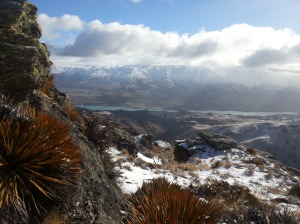
It is the middle of winter here. The wind was screaming in from the south and about half way up I reached a snow line of sorts. The last half hour of the walk was in ankle deep snow and bitterly cold winds which I was not appropriately dressed for at all. I had to hide behind an outcrop of rocks just so I could maintain enough feeling in my fingers to take a picture!
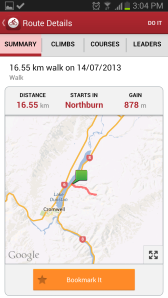
I had MapMyRide going again in my pocket. A woman’s voice speaks out every kilometre, telling you how long you have been working out and split times for your k’s. At the beginning I was averaging 11minutes per km, at the top she said 14mins/km and then on the way down 9mins/km. Total distance 16.55km and a climb of 878m. Not a bad effort at all in 3hours and 15minutes.
A good training outing I reckon, after reading the Northburn Station 50km stats, this track will be very useful. In fact, I think part of it is actually used in the race. Is it cheating?
Until next time, thanks for reading!


July 14th, 2013 at 9:29 am
Nope – not actually part of the track but yes, right beside it and very good training! Love your work! Can I link this blog to the NB100 website?
July 15th, 2013 at 6:13 am
Sure! Wow, for such an amateur at blogging and endurance training, what an honour. Thank you!
July 15th, 2013 at 6:54 am
You are now linked via the 50k page. You’ll have to keep it up now!
When I’m back to some level of fitness (still in rehab mode) I’ll be keen to come out for a run/tramp with you. (Terry)
July 15th, 2013 at 8:24 am
Haha no pressure! – but the whole point of the blog…
You’ll have to give me some pointers! I still don’t think I really know what I’m getting myself into!